Rounds of torrential rains bring life-threatening flash flooding, record river flooding to Upper Midwest
As an area of low pressure slowly drifts across the Upper Midwest Saturday, widespread rainfall totals of 2-4 inches are likely through Saturday afternoon while Rock Valley, Iowa suffers a river levee break forcing urgent evacuations.
Multiple rounds of torrential rain and thunderstorms in the Upper Midwest have created both a significant flash flooding risk Saturday and potentially record river flooding into early next week, with one swollen river already breaking a levee in Iowa and forcing urgent evacuations.
As an area of low pressure slowly drifts across the Upper Midwest Saturday, widespread rainfall totals of 2-4 inches are likely through Saturday afternoon, with some storms exceeding 5 inches.
Rainfall rates in the heaviest storms are expected to be over 1 inch per hour, and if storm activity could sit over the same areas, life-threatening flash flooding and rapid-rise river flooding could occur.
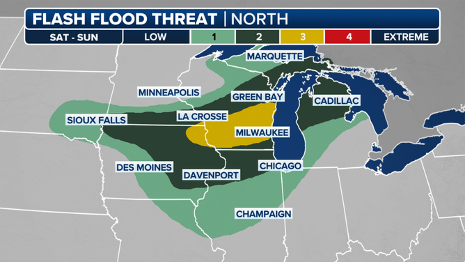
NOAA’s Weather Prediction Center has placed much of southern Wisconsin, including Milwaukee and Madison, inside a level 2 out of 4 risk of Flash Flooding on Saturday.

But all that rain is falling over an area that is already extremely saturated after multiple waves of heavy rain have rolled through the region, triggering fears of extensive river flooding as well.
Radar estimates indicate 8–12 inches of rain have already fallen in South Dakota and Minnesota over the last several days. The ground has no chance to dry, leading to fast runoff of water into the river basins and rapid water rise.
7 FACTS YOU SHOULD KNOW ABOUT FLASH FLOODS
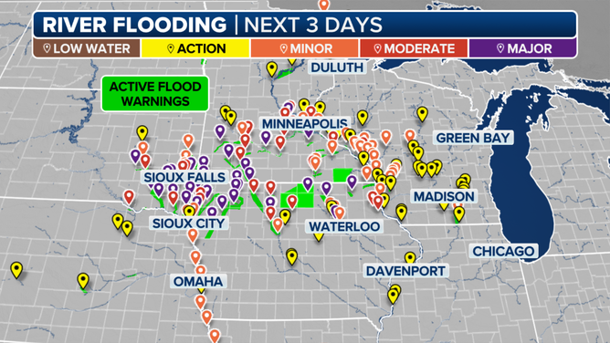
Forecast models indicate dozens of rivers will reach moderate or major flood stage across southeastern South Dakota, northern Iowa and southern Minnesota.

Midwest River Stages Forecast
Multiple river gauges could record their all-time highest crest over the coming days, according to the FOX Forecast Center.
River basins in Iowa could see the worst of it as they sit downstream of the heaviest rain with the Big Sioux, Little Sioux, Ocheyedan, and Des Moines rivers among those forecast to exceed their record flood stage.

(FOX Weather)
Levee break leads to Flash Flood Emergency in northern Iowa
Already swollen rivers and heavy rains caused a levee to break along the Rock River in Rock Valley, Iowa, early Saturday morning, leading to urgent evacuations and a Flash Flood Emergency.
FLOOD WATCH, WARNING AND EMERGENCY: HERE ARE THE DIFFERENCES THAT COULD SAVE YOUR LIFE
"We are setting off sirens in (Rock Valley)," the Sioux County Sheriff’s Office posted on social media. "This means to evacuate your house if able."
Rock Valley city officials have been posting updated maps on their town's social media feeds showing growing areas of evacuation orders as waters rise. The sheriff’s office reported at least two bridges and road had washed out.
"We have boats and emergency personnel coming in from neighboring towns," city officials posted on social media. "Please continue to stay home if you are not in the emergency evacuation areas. Plans are being made for further evacuations. We will continue to highlight areas of town on the map with anticipated evacuations."
HOW FLOODWATER CAN MAKE YOU VERY SICK
A shelter was established at a local church, but more help was needed.
"Rock Valley area farmers, if you can safely get to Rock Valley, please come with tractors and loaders to help with evacuations," city officials asked.
Emergency officials also had their hands full in Iowa’s O’Brien County with widespread flooding and multiple rescues.
"O’Brien County first responders have performed several water rescues of people trapped in their vehicles after being swept away," county officials posted on social media. "The flooding has created significant challenges for first responders trying to get to these scenes. County roads and the Iowa DOT are doing their best to put up barricades but the widespread flooding has their resources stretched thin."
Severe weather an added danger this weekend
Not only will those in the Upper Midwest be monitoring for dangerous flooding, but severe storms will also be moving through the Midwest into the weekend.
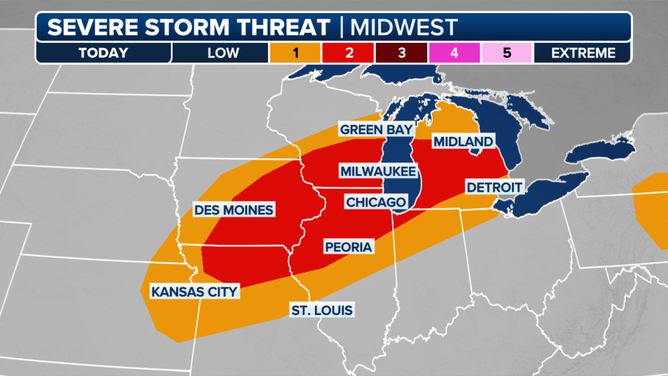
Several major cities including Chicago, Milwaukee, and Des Moines, Iowa could experience severe storms capable of tornadoes, damaging wind and large hail.
NOAA’s Storm Prediction Center has all of those cities in a Level 2 of 5 risk for severe weather on Saturday.

"I think that that really begins to flare up between lunch and dinner (Saturday)," said FOX Weather Meteorologist Michael Estime. "So if you have any late lunch plans or early dinner plans right there, you can see (the storms) stretching from Green Bay to Milwaukee and then back to Des Moines. Another round of heavy showers (with) strong to severe storms erupts (and) blasts through Chicago late this evening after sunset before making its way down around Peoria, Illinois."
The severe weather threat shifts out of the Midwest and into the Northeast on Sunday
No comments: