New Orleans under Flash Flood Emergency after tornado strikes Texas in severe weather outbreak
The Flash Flood Emergency in the New Orleans metro will remain in effect until 2 p.m. CDT for north-central Jefferson Parish, southwestern Orleans Parish and west-central St. Bernard Parish.
A Flash Flood Emergency is in effect for the city of New Orleans as a severe weather outbreak unfolds Wednesday with numerous thunderstorms rolling across the lower Mississippi Valley and Southeast.
Emergency management reported numerous roads and underpasses in and around New Orleans were underwater and impassible shortly before 11 a.m. CDT Wednesday. Doppler Radar estimated rainfall rates of 1-3 inches per hour, with some isolated spots reaching up to 4 inches per hour.
The National Weather Service in New Orleans has reported thunderstorm wind gusts of up to 71 mph at a fire station just east of the city. Wind damage has been reported around Slidell, located north of New Orleans, including a tree that fell onto a home in Pearl River.
Watch: Likely tornado leaves behind significant damage in Slidell, Louisiana
Police in Slidell, Louisiana, shared this video on Facebook describing the significant damage left behind when a likely tornado ripped through the community on Wednesday morning.
The Flash Flood Emergency in the New Orleans metro will remain in effect until 2 p.m. CDT for north-central Jefferson Parish, southwestern Orleans Parish and west-central St. Bernard Parish.

(FOX Weather)
Emergency officials are also closely monitoring a potential levee break near a subdivision on Highway 16 in Yazoo County, Mississippi. All residents in the area have been evacuated for their safety.
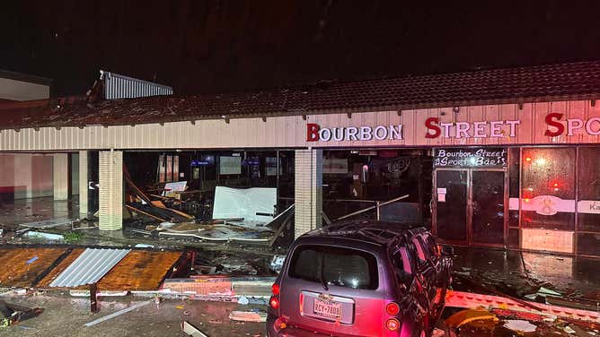
On Wednesday morning, tornado damage was reported in southeastern Texas. According to a storm survey conducted by the NWS, damage in Katy appears to have been caused by an EF-1 tornado with a track and estimated maximum winds of 90 mph.
Possible tornado causes building collapse in Katy, Texas
Powerful thunderstorms and a possible tornado tore across the Houston suburb of Katy, Texas, early Wednesday morning. FOX 26 Reporter Shelby Rose joined FOX Weather from Katy where a building collapsed during the severe weather.
The National Weather Service in Houston is currently sending survey crews to determine whether the damage was caused by straight-line winds or if it was indeed a tornado.
HOW TO WATCH FOX WEATHER
A Tornado Watch is in effect for southeastern Louisiana and central and southern Mississippi until 1 p.m. CDT. A second Tornado Watch has been issued for portions of southern Alabama and the Florida Panhandle until 5 p.m. CDT.
HOW LONG DO TORNADOES LAST AND HOW DO THEY FORM?
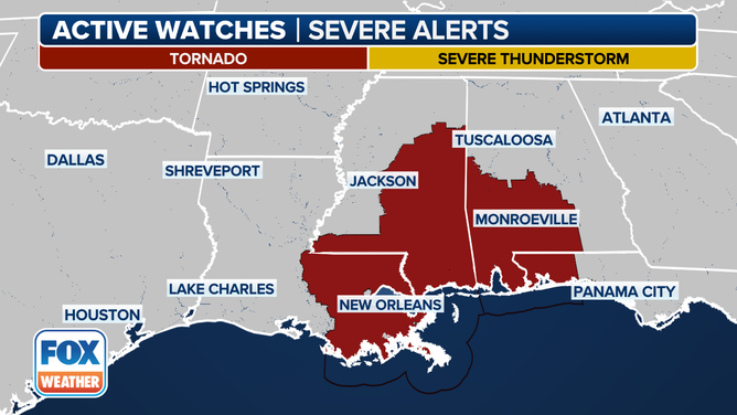
A look at the active Tornado and Severe Thunderstorm Watches issued for Wednesday, April 10, 2024.
(FOX Weather)
Just after 8 a.m. CDT, a "Particularly Dangerous" Tornado Warning was issued for New Roads, Louisiana by the National Weather Service in New Orleans. But the NWS canceled the warning a short time later and said a tornado was not observed.
In addition, a Flash Flood Emergency has been posted in Kirbyille and Newton in southeastern Texas, where over 8 inches of rain has fallen in the past 24 hours.
"This is just the beginning. There's not going to be a break today. It's going to be very busy across the Gulf states," FOX Weather Meteorologist Britta Merwin said.
FLASH FLOOD EMERGENCY ISSUED IN TEXAS AS LIFE-THREATENING FLOODING SWAMPS SOUTH
Kirbyville, Texas underwater during Flash Flood Emergency
Water rescues are underway in Kirbyville, Texas on Wednesday as Flash Flood Emergency unfolds across East Texas. Kirbyville Mayor George Frank said the rain is still coming down after nearly a foot has already fallen.
The central Gulf Coast faces the greatest severe weather threat on Wednesday, with a Level 4 out of 5 rating from NOAA's Storm Prediction Center (SPC). This includes more than 2 million people in portions of Louisiana, Mississippi and Alabama.
DRAMATIC VIDEO SHOWS FLOODWATERS ENTERING FIRE TRUCK AFTER WATER RESCUE IN TEXAS AMID WIDESPREAD SEVERE STORMS
Torrential rains fall along New Orleans' Burbon Street on Wednesday morning
Torrential rains fall along New Orleans' iconic Burbon Street on April 10, 2024.
"It is significant when you look at how many times we get a 4 out of 5 alert for severe weather from the SPC during the peak of spring severe weather season, which we're now entering," Merwin said. "We will sometimes get two of those a month. So really put that in perspective."
An even broader area of the South, from Louisiana to the Florida Panhandle, is at a Level 3 out of 5 risk of severe weather. More than 5 million people live within this risk zone.
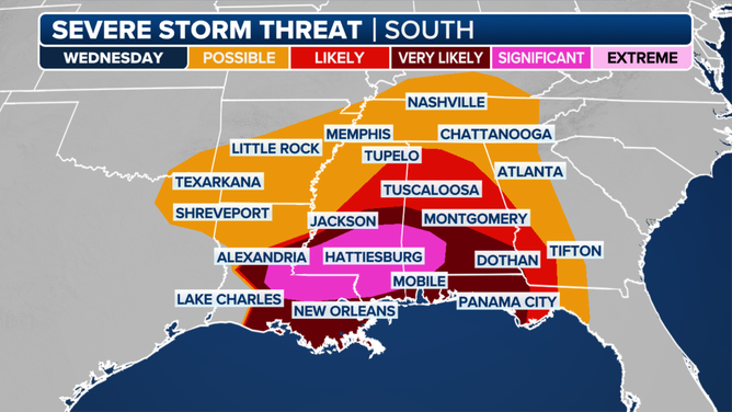
This graphic shows the severe weather threat on Wednesday, April 10, 2024
(FOX Weather)
During the morning hours, Louisiana is at risk of tornadoes and destructive wind gusts due to a thunderstorm complex rolling across the state. Some of the tornadoes could be EF-2 or stronger. As temperatures rise throughout the day, the storms will intensify and move into Mississippi. Additionally, thunderstorms could develop into intense lines of storms, resulting in 75-plus-mph wind gusts that would have the potential to cause widespread damage.
The SPC is warning of potentially widespread damaging winds, some of which may be "particularly damaging." Large hail is also possible, but the threat of hail is lower than Monday and Tuesday.
6 TYPES OF CLOUDS YOU MIGHT SEE DURING SEVERE STORMS
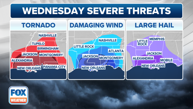
A look at the severe weather threats on Wednesday, April 10, 2024.
(FOX Weather)
"With the weather that's moving through the Gulf states this morning and what we're expecting throughout the day today, the real message is stay home, stay safe," Merwin added. "You don't want to be away from a safe area on a day like today."
Some Louisiana schools, colleges and governments have already canceled classes and closed offices Wednesday due to the severe weather threat. Ascension Public Schools in Donaldsonville, Louisiana, said its "particular concern is the possibility of wind gusts up to 70 mph, which puts student travel at risk."
New Orleans also announced all city offices would be closed Wednesday as well.
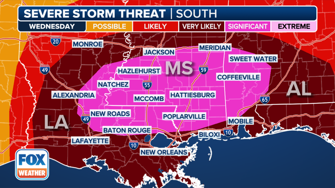
This graphic shows the severe weather threat on Wednesday, April 10, 2024.
(FOX Weather)
Once the sun sets Wednesday evening, the threat of tornadoes and damaging winds will continue as storms move across southern Alabama, the Florida Panhandle and southwestern Georgia.
NIGHTTIME TORNADOES: HOW YOU CAN STAY SAFE FROM NOCTURNAL TWISTERS
South also faces potential for life-threatening flooding
It's not just the lightning, hail, wind and possible tornadoes threatening the South, but the multiple inches of rain that could trigger life-threatening flooding across parts of the region.
Flood Watches stretch from East Texas to the Florida Panhandle and southwestern Georgia.
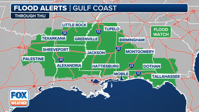
A look at the flood alerts posted in the South.
(FOX Weather)
Already, over 8 inches of rain has fallen in Texas. Multiple Flash Flood Warnings have been issued across the South since Monday, including a Flash Flood Emergency in Kirbyille and Newton in southeastern Texas on Wednesday morning.
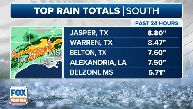
A look at the top rain totals in the South in the past 24 hours.
(FOX Weather)
Due to flooding, all major roads into Kirbyville were closed Wednesday morning. Multiple fire departments deployed from around the region are conducting rescue efforts in the area.
"We have major flooding throughout the county at the midline with another line of storms coming," the Jasper County Sheriff’s Office said.
Roganville fire truck submerged in floodwater as heavy rain pounds Texas
On Wednesday morning, volunteer firefighters from the Roganville, Texas, Fire Department responded to a high-water rescue. They had to wait for a front loader to pull them out of the floodwaters.
The FOX Forecast Center said repeated rounds of storms capable of torrential rain will continue to lash the region through Thursday.
These storms will have the potential to drop copious amounts of rain in a short time, with rainfall rates over 2 inches an hour expected.
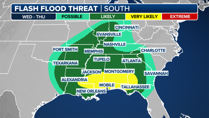
A look at the flash flood threat in the South through Thursday, April 11, 2024.
(FOX Weather)
Many of these storms will happen at night, which only increases the danger. Helping to increase the flood threat is the fact that the soils remain wet from a soggy start to 2024.
Many locations have seen rainfall totals of 5- to 7-plus inches above average for the year. In addition to the flash flood threat, multiple rivers from Texas to Mississippi are expected to rise into flood stage, including the Trinity and Sabine rivers in Texas and the Ouachita River in Arkansas.
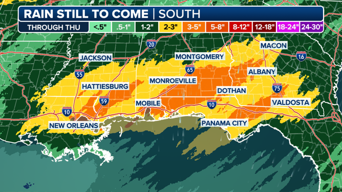
This graphic shows the rainfall forecast through Thursday, April 11, 2024
(FOX Weather)
Georgia, Florida and South Carolina will be the focus Thursday
Attention will shift to the Southeast on Thursday, particularly across Florida, Georgia and southern South Carolina.
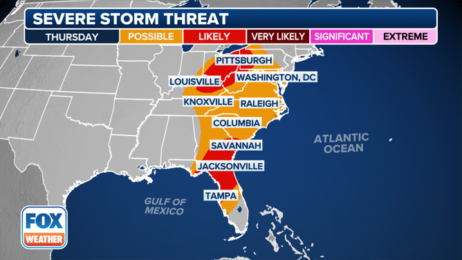
This graphic shows the severe weather threat on Thursday, April 11, 2024.
(FOX Weather)
Computer forecast models suggest that a line of strong to severe thunderstorms will march east across the region during the morning. It remains uncertain whether that will be the primary driver of the severe weather threat or if additional severe storms develop that afternoon.
The primary threat with these storms will be 60-plus-mph wind gusts, along with quarter-sized hail.
Tuesday's severe storms hit Texas, Louisiana
Severe thunderstorms swept through parts of Texas and Louisiana on Tuesday night. The storms were intense, and a handful of Tornado Warnings and dozens of Severe Thunderstorm Warnings were issued throughout the region.
Hail hammers Salado as severe storm moves across Texas
Hail hammered Salado, Texas, as a severe storm moved across the state on Tuesday. This video of large hailstones and lightning was captured by Chad Casey, who said he filmed it in Salado.
Strong storms brought an 88-mph wind gust to Briscoe, Texas, while Knox City, Texas, gusted to 78 mph. Some storms in Texas also produced baseball- and tennis ball-sized hail, including a report of tennis ball-sized hail in Austin.
No comments: