Spring storm to unleash heavy snow, severe weather across US this weekend into next week
One of the worst snowstorms since last winter is expected to bury the northern Plains and Upper Midwest, while severe storms and heavy rain are likely on the warm side of the storm in the South.
A major early-spring storm is expected to arrive with a bang starting this weekend and continuing into next week, as it brings heavy snow, ice, severe storms and colder air, affecting a wide swath of the country.
Driving this potential storm is a blocking pattern well to the north in Alaska and Canada, the FOX Forecast Center said. This will allow for an extended dip in the jet stream across the Rockies, creating a significant cold-air intrusion into the central U.S.
HOW TO WATCH FOX WEATHER

(FOX Weather)
Those farther south can expect southerly winds to strengthen, transporting moisture northward out of the Gulf of Mexico. This overlap of warm, moisture-rich air from the south with arctic air from the north could lead to the formation of a high-impact storm.
Powerful storm system forms east of Rockies
The storm will first make its presence known this weekend across the West. Heavy snow will fall across almost every major mountain range from California's Sierra Nevada to Colorado's Front Range. Multiple feet of snow is possible, especially in the Sierra, the FOX Forecast Center said.
At lower elevations, moderate rain will fall in the major cities along the Interstate 5 corridor, including Seattle, Portland in Oregon and Sacramento in California. Some flooding will be possible along the coastal sections of Northern California and Oregon as a weak atmospheric river sends increased moisture to these areas from Friday into Saturday.

(FOX Weather)
WHAT IS AN ATMOSPHERIC RIVER?
The rain will shift down to Southern California from Saturday into Sunday but should remain light enough to mitigate any flooding concerns, the FOX Forecast Center said.

(FOX Weather)
The focus will then shift to the central U.S. due to the development of a strong surface low-pressure system east of the Rockies that is expected to track toward the Midwest by Monday morning.
WHEN CAN YOU EXPECT THE LAST SNOW OF THE SEASON?

(FOX Weather)
Confidence continues to grow that heavier wet snow with gusty winds will slam the northern Plains and Upper Midwest starting Saturday. This will be a long-duration event with multiple waves of precipitation potentially lasting through Tuesday or Wednesday.
Significant snowfall accumulations are likely, the FOX Forecast Center said, and the storm may be the worst to hit the region since last winter.

(FOX Weather)
Just south of the heavy snow, FOX Weather meteorologists will be watching for the potential of sleet or even freezing rain, which would lead to dangerous travel conditions and potential power outages. Where exactly this icy mix sets up remains uncertain, but the general corridor looks to be from central Nebraska into southern Wisconsin.
South severe storm threat driven by clashing of temperatures
On the warm side of the system, multiple rounds of showers and thunderstorms, some of which could be strong to severe, can be expected from Texas to the Ohio Valley.
BUZZWORDS YOU COULD HEAR DURING SEVERE WEATHER

(FOX Weather)
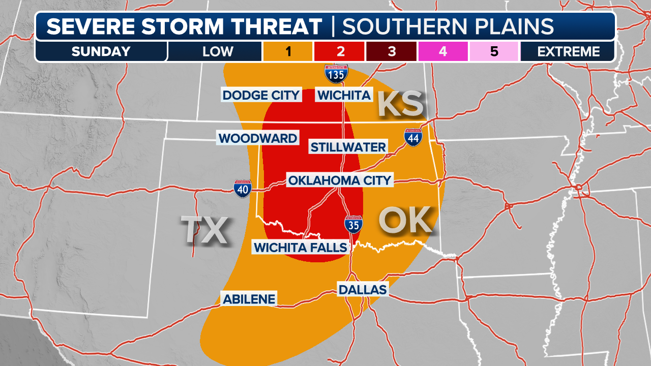
NOAA's Storm Prediction Center has already highlighted a severe storm threat for Sunday in the central and southern Plains from central Kansas to northwestern Texas.
This severe weather threat will consist of a few supercells initially, followed by a narrow evolving squall line that will pose an increasing risk of damaging winds, large hail and a couple of tornadoes. The threat will diminish late Sunday evening.

(FOX Weather)
By Monday, the risk of severe storms is expected to shift east into the lower Mississippi Valley and mid-South.
The primary severe weather threat will be later in the day with the formation of supercells and a developing squall line that could maintain strength throughout the evening before weakening overnight.

(FOX Weather)
As the storm moves through, powerful northerly winds will bring cold air down from Canada and across the Rockies and Plains, where it will linger.
High temperatures will be 10-30 degrees below average for this time of year, and the long-range outlooks indicate that the chill will last through the end of the month across the country's western half.

No comments: