Relentless rains to drench Gulf Coast through St. Patrick's Day weekend
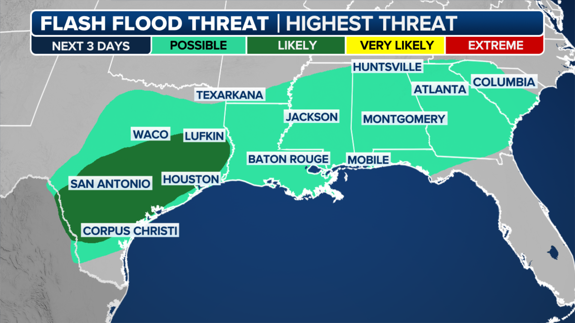
Forecast models show 2-4 inches of rainfall falling in some communities from Central Texas to New Orleans. Houston only typically sees around 3.50" of precipitation during March, meaning the metro area might see nearly an entire month’s worth in just four – A frontal boundary that helped produce deadly tornadoes in the Ohio Valley and softball-sized hail over the Plains is not expected to move much over the next few days, making for a wet St. Patrick’s Day weekend along the Gulf Coast//
The FOX Forecast Center said due to the instability and moisture present, showers and thunderstorms will be possible at any time but favor locales along the Interstate 10 corridor.
Any storms that develop have the potential of turning strong to severe, with cloud-to-ground lightning, hail and gusty winds reaching 50 mph or more.

(FOX Weather)
"So, how much rain are we talking? Well, it really depends on where you are," said FOX Weather meteorologist Jason Frazer. "The possibility for seeing anywhere from 2 to 3 inches of rain is going to be for places like San Antonio, as well as Houston, and even stretching just to the south of the Jackson, Mississippi area."
Forecast models show the heaviest precipitation will fall over Texas and next-door Louisiana, with values that could reach 2-4 inches by the time the event is over.

(FOX Weather)
In communities where the ground is already saturated, flash flooding will be a possibility, but widespread life-threatening impacts are not expected.
At least 45 water level gauges along rivers and tributaries in the Lower Mississippi and Southeast are at flood stage, as an active El Niño pattern has resulted in a fairly wet start to the year for communities such as Atlanta, New Orleans and Tallahassee, Florida.
SEVERE WEATHER OUTBREAK LEAVES AT LEAST 3 DEAD AS TORNADOES TEAR ACROSS MULTIPLE STATES
(FOX Weather)
At least 45 water level gauges along rivers and tributaries in the Lower Mississippi and Southeast are at flood stage, as an active El Niño pattern has resulted in a fairly wet start to the year for communities such as Atlanta, New Orleans and Tallahassee, Florida.
WHAT DOES RAIN SMELL LIKE?
Popular March events to be mostly spared from wet weather
Fortunately for planners and attendees of St. Patrick’s Day celebrations in Savannah, Georgia and THE PLAYERS Championship in Ponte Vedra Beach, Florida, both events appear to be largely spared from turbulent weather.
The 200th St. Patrick’s Day Parade in Savannah took place on Saturday morning but events to commemorate Saint Patrick and Ireland’s Christianity are expected to continue all weekend long.
According to the FOX Forecast Center, the weekend will feature highs around 80 degrees, with the possibility of a few showers on Sunday evening.

FILE – St. Patrick’s Day celebrations in Savannah, Georgia appear to be largely spared from turbulent weather.
(City of Savannah Government)
Less than 150 miles away, thousands of golf fans are expected to line the course in Northeast Florida for the annual THE PLAYERS Championship.
In the past, the PGA tournament has been the subject of washouts, but during this year’s event, only scattered storm chances will exist during the final round.
The FOX Forecast Center expects the entire region to begin to dry out late Monday as a ridge of high pressure and cooler temperatures set in.


No comments: