Severe storms target South bringing threat of tornadoes, damaging winds, flooding
The severe weather threat kicks off Monday evening with an overnight threat of tornadoes for parts of Texas, Louisiana, Mississippi, Alabama and the Florida Panhandle.
A stormy and windy start to the workweek looms for the South as the FOX Forecast Center is tracking a potent multiday storm threat from Texas to the Carolinas, bringing the threat of severe weather, including tornadoes, damaging winds and hail.
Severe thunderstorms will take aim at the South beginning Monday as a strong dip in the jet stream sends energy into the Gulf Coast and intersects with warm, moist air from the Gulf of Mexico surging north.
"It's pretty impressive because we have the cold air right from the blizzard that's going to be coming in, and we've got warm, moist air from the Gulf," FOX Weather Meteorologist Amy Freeze said. "So that boundary along the Southeast is what starts to get pretty feisty."
On Monday and into Monday night, NOAA’s Storm Prediction Center issued a Level 2 out of 5 severe weather risk for an area including 13 million people from southeastern Texas to the western Florida Panhandle.
U.S. SEVERE THUNDERSTORM WARNING MAP
According to the FOX Forecast Center, the return of moisture from the Gulf of Mexico will destabilize the atmosphere, providing a significant risk of severe thunderstorms starting late Monday along the Gulf Coast. The primary weather concerns will be heavy rain, damaging winds and hail, with the potential for a tornado or two.

(FOX Weather)
This severe weather risk includes Houston, New Orleans, Mobile in Alabama and Panama City in Florida and goes through Monday night.
This weather setup is particularly dangerous because of the timing, as the biggest severe weather threat is from overnight Monday into Tuesday. Tornadoes that happen at night are more than twice as likely to be deadly than daytime tornadoes.
NIGHTTIME TORNADOES: HOW YOU CAN STAY SAFE FROM NOCTURNAL TWISTERS
"The pre-dawn hours into Tuesday look particularly dangerous as that squall line starts to develop," Freeze said. "The storms are going to go overnight. The low is going to deepen. That means we could get some very heavy rain coming in. Places like Atlanta could see just incredible amounts of moisture over a 48-hour period."

(FOX Weather)
On Tuesday, the severe weather threat will push east from Florida into the Carolinas. There is a Level 2 out of 5 risk for severe thunderstorms across southeastern Alabama, much of North and Central Florida and through the Carolinas.
Again, the primary threats will be damaging wind gusts and the possibility of tornadoes.
Flash flooding threatens New Orleans
The FOX Forecast Center is tracking impressive rain totals from Monday through Wednesday that could cause flooding problems across the Gulf Coast and Carolinas.

(FOX Weather)
NOAA’s Weather Prediction Center (WPC) has issued a Level 3 out of 4 flash-flood risk on Monday for southeastern Louisiana, southern Mississippi and southern Alabama. The greatest flooding potential is forecast for more than 4.3 million people across major southern cities, including New Orleans, Biloxi in Mississippi and Mobile in Alabama.
HERE'S WHAT TO DO AFTER YOUR CAR IS FLOODED

(FOX Weather)
A wider area faces a Level 2 out of 4 flash-flood risk, including Lake Charles and Alexandria in Louisiana, Jackson in Mississippi and Montgomery in Alabama.
Beginning Monday, the WPC is forecasting rainfall rates up to 2.5 inches per hour, leading to localized rain totals up to 6 inches.
Flooding is more likely for urban areas and pockets of the Gulf Coast where rain has fallen more recently, making those areas sensitive to flooding.
HOW TO WATCH FOX WEATHER
The flooding threat shifts into the Southeast from Georgia into the Carolinas on Tuesday and Wednesday.
Rainfall totals through Wednesday could reach up to 5 inches for parts of the Florida Panhandle, including Panama City, northeastern Georgia and the western Carolinas. Cities including Atlanta, New Orleans and Mobile, Alabama, could see up to 3 inches of rain, with up to 5 inches in Charlotte, North Carolina, and Tallahassee, Florida.
Powerful winds to blast New Mexico, the South and Great Smoky Mountains
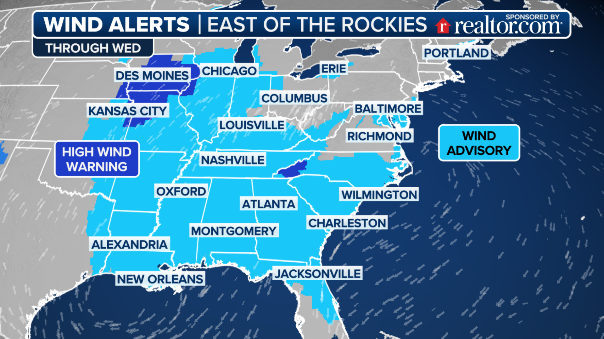
This multiday weather event includes powerful winds, with gusts between 50 and 80 mph.
Wind Advisories and High Wind Warnings are in place through Tuesday for the Southwest from New Mexico to Texas and for the South from the Gulf Coast to the Florida Panhandle. A High Wind Warning is also in place for the Great Smoky Mountains of East Tennessee.
(FOX Weather)
Wind Advisories are in place for south-central and southwestern New Mexico from Sunday through Monday morning. Sustained winds up to 35 mph with gusts up to 50 mph are possible for cities including Truth or Consequences, Deming and Las Cruces, New Mexico. Gusty winds are also forecast for El Paso, Texas.
Southeastern Louisiana and southern Mississippi are forecast to see southerly winds between 25 and 35 mph with 50-mph gusts. A Wind Advisory is in effect from Monday afternoon through Tuesday morning.
A High Wind Watch is in place through Tuesday evening for parts of the Great Smoky Mountains and the foothills in East Tennessee.

(FOX Weather)
Southeasterly winds between 40 and 50 mph are forecast, with gusts up to 80 mph for cities including Gatlinburg, Mountain City, Elkmont and Hampton.


No comments: