Developing nor’easter puts 45 million on alert as winter storm eyes Northeast this weekend
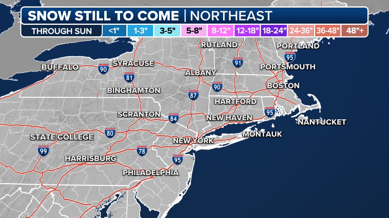
Several inches of snow is likely across swaths of the interior Northeast and New England, with impactful snow totals along the northern Interstate 95 corridor, including Boston. Perhaps there is even enough snow in New York City to be the city's largest snowfall in two years – though the bar is quite low.
The Northeast is bracing for an onslaught from a nor'easter this weekend, which is expected to be the East Coast's first major winter storm of the year.
About 45 million Americans from Georgia to Maine are under winter weather alerts as the storm could bring heavy snow, strong winds and dangerous ice.
'Brief but heavy' snowsquall as Massachusetts braces for nor'easter
A Massachusetts resident captured a
Widespread Winter Storm Warnings are in effect for several inches of snow across swaths of the interior mid-Atlantic, Northeast and New England, including Boston and the northern Interstate 95 corridor.
An ocean influence with water temperatures in the 40s and 50s will keep coastal communities from New York City southward from seeing much accumulation.
WEEKEND NOR'EASTER LIVE TRACKER: LATEST FORECAST, LIVE RADAR, SNOWFALL TOTALS AND MORE

(FOX Weather)
Storm system impacting Southeast now
The storm system began to organize Friday across the southern U.S. with heavy rain and even snow in Oklahoma and Arkansas.
This strong area of low pressure continues to strengthen on Saturday as it moves up the Eastern Seaboard, and will peak on Saturday night into Sunday for the mid-Atlantic and Northeast states. Heavy snow is expected in a region generally from Pennsylvania to New England.
Many factors of the forecast could still change, as nor'easters are notoriously difficult to predict amid their balance between warm and cold air. The I-95 corridor is particularly tricky due to its proximity to warmer ocean waters and its sensitivity to wind direction based on the placement of the low-pressure system.
(FOX Weather)
In this case, warm air in the mid-levels will wrap around the system, making the rain-snow line uncertain for major cities along the I-95 corridor.
West of I-95, temperatures will stay cool enough for all snow, and the big winner of the storm will be upstate New York, northeastern Pennsylvania and New England. It is here that the heavy snow will linger the longest, according to the FOX Forecast Center.
Cities such as Boston and Worcester in Massachusetts, Manchester in New Hampshire, Hartford in Connecticut, Albany in New York, Providence in Rhode Island and Scranton in Pennsylvania have a high likelihood of seeing 6-plus inches of snow. Harrisburg, Pennsylvania, should have no problem ending its record snowless streak.
WHAT THE '40/70 BENCHMARK' MEANS FOR SNOW FORECASTS

(FOX Weather)
The snow is expected to be wet and heavy versus dry and powdery. Heavy snow and strong wind gusts may lead to downed trees and power outages.
New York City faces tricky snow forecast
According to the latest forecast, temperatures along the I-95 corridor south of New York City will remain several degrees above freezing. This means that the current record streak of consecutive days without an inch of snow is likely to continue in Philadelphia and Baltimore, according to the FOX Forecast Center said.
It is an incredibly tricky and uncertain forecast for New York City as the city will be on the rain-snow line for much of the storm. While it has a chance of breaking the nearly two-year streak of no 1-inch snow days, the forecast accumulations for the nor'easter have been trending downward in the Big Apple.
HOW MUCH SNOW WARRANTS A WINTER STORM WARNING?

(FOX Weather)
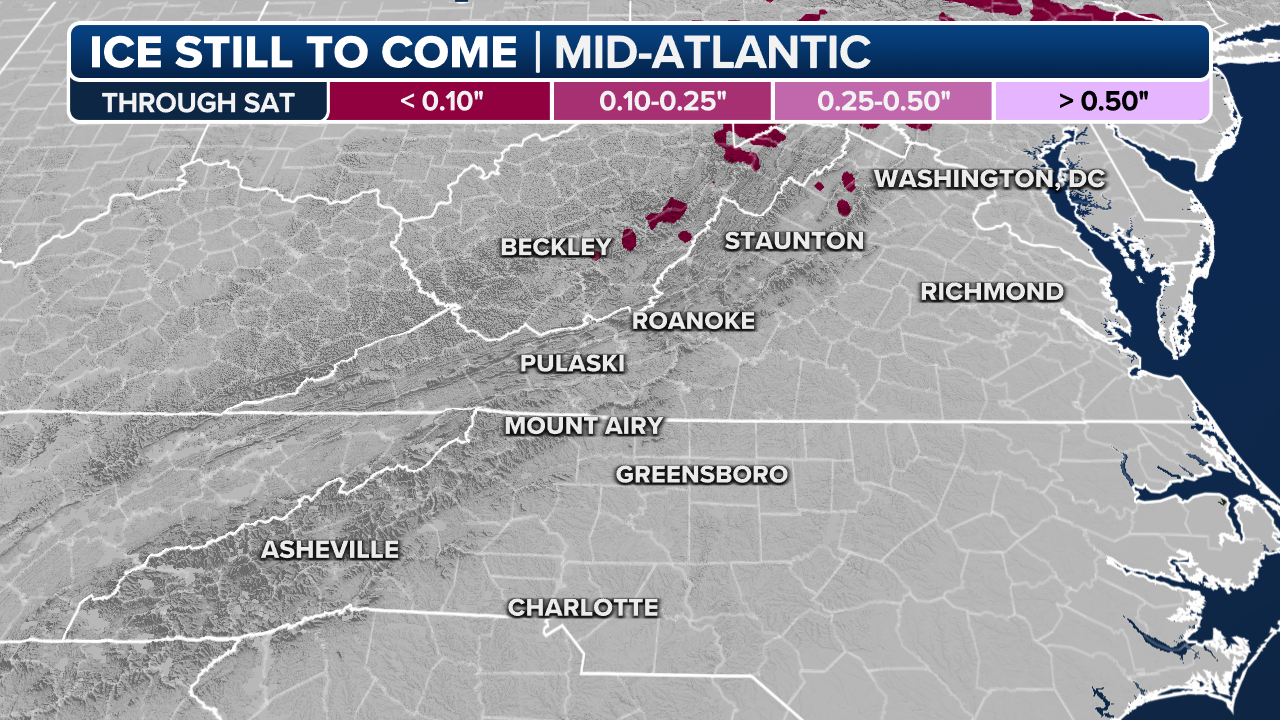
Freezing rain an issue Saturday along Appalachian Mountains
It's not snow or rain but ice that will be an issue with this nor'easter as it passes near the Appalachian Mountains on Saturday. Cold air has dammed against the mountains while warm air advances above it, creating dangerous freezing rain.
Freezing rain to create dangerous ice accretions along Appalachians
Ice accretions of up to a quarter inch are likely Saturday morning along western North Carolina and Virginia as the developing nor'easter spread across the Appalachians.
Ice accretion rates were expected to reach 0.05 to 0.15 inches per three hours by later Saturday morning along the spine of the Appalachians in western North Carolina and Virginia as the storm crawled up the mid-Atlantic. Already, Rutherford, North Carolina reported 0.20 inches of ice accretion early Saturday morning.
(FOX Weather)
Freezing rain can glaze roads with a sheet of ice, and topple trees and power lines, creating power outages. Warmer temperatures will change freezing rain to rain by late morning into midday hours from south to north as the storm tracks toward the Northeast.
Meanwhile, mountain wave winds are blowing along the eastern Tennessee sections of the Appalachians.
A wind gust reached 80 mph in a wind prone location of Camp Creek, Tennessee while Cove Mountain Fire Tower reached 71 mph early Saturday morning. High Wind Warnings are in effect there through 10 a.m. local time.


No comments: