East Coast storm slams Northeast with flooding rain, high winds as power outages skyrocket
Nearly 200,000 customers were without power from New York and New Jersey to New England early Monday morning due to strong, gusty winds knocking down tree limbs and power lines. Power outage numbers are expected to continue to rise as the storm impacts the region, and restoration efforts are being slowed due to the conditions.
EW YORK – After slamming Florida with tropical-storm-like conditions on Saturday and prompting Flash Flood Emergencies along the South Carolina coast on Sunday, a powerful storm system will continue to slide up the East Coast on Monday, packing threats of flooding, high winds and severe weather that could disrupt pre-Christmas travel for millions in the Northeast and mid-Atlantic states.
HOW TO WATCH FOX WEATHER
Where is the East Coast storm now?
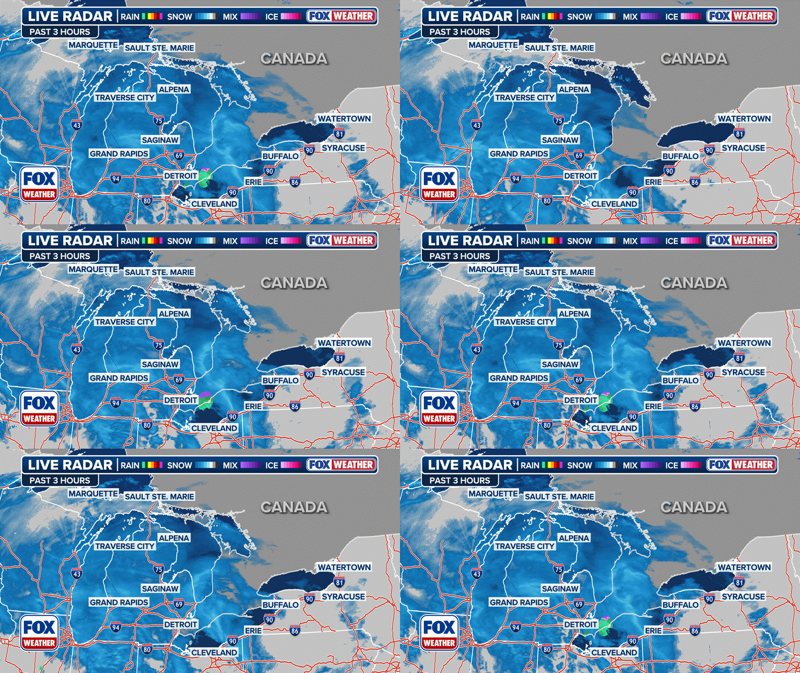
Heavy rain, gusty winds, flash flooding and coastal flooding were impacting areas across the Northeast and mid-Atlantic on Monday morning. The storm will continue tracking north throughout the day.
(FOX Weather)
Power outages starting to skyrocket in the Northeast, New England
According to PowerOutage.US, more than 430,000 customers were without power from New York and New Jersey to New England early Monday morning due to strong, gusty winds knocking down tree limbs and power lines.
Connecticut and Massachusetts so far, are experiencing the worst when it comes to power outages. Connecticut is experiencing over 86,000 outages and Massachusetts has reported just under 100,000 outages.

Power outages in the Northeast and New England on Monday, Dec. 18, 2023.
(FOX Weather)
Tens of thousands of power outages have also been reported across the Northeast and New England as the storm continues to slam the region with heavy rain and high winds.
Power outage numbers are expected to continue to rise as the storm impacts the region, and restoration efforts are being slowed due to the conditions.
Utility crews can't begin to make repairs and restore power until conditions begin to improve.
What is the timing of the East Coast storm?
Rain and high winds will continue Monday across the Northeast and New England.
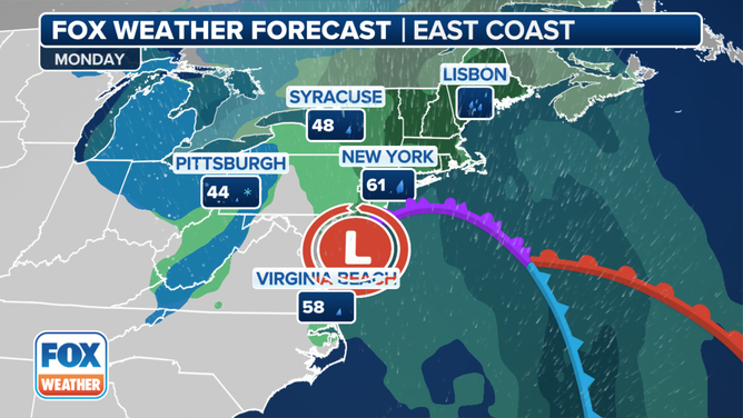
The forecast for Monday, Dec. 18, 2023.
(FOX Weather)
In interior sections of the Northeast, Great Lakes and Appalachians, the rain could change over to a period of accumulating snow late Monday and into Monday night.
HOPE FOR WHITE CHRISTMAS WANING AS LIMITED OPPORTUNITIES FOR SNOW SEEN THIS WEEK
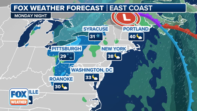
The forecast for Monday night, Dec. 18, 2023.
(FOX Weather)
Where is the heaviest rain expected in the Northeast and Southeast?
The National Weather Service has issued Flood Watches through Monday night for more than 42 million people in the eastern U.S.
FLOOD WATCH, WARNING AND EMERGENCY: HERE ARE THE DIFFERENCES THAT COULD SAVE YOUR LIFE
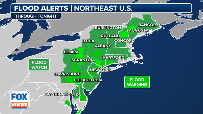
Flood Watches are in effect for the Northeast through Monday, Dec. 18, 2023.
(FOX Weather)
A widespread 2 to 4 inches of rain is predicted to fall across the Northeast and New England.
Localized rainfall totals between 4 and 6 inches are possible in some locations, particularly near the coast.
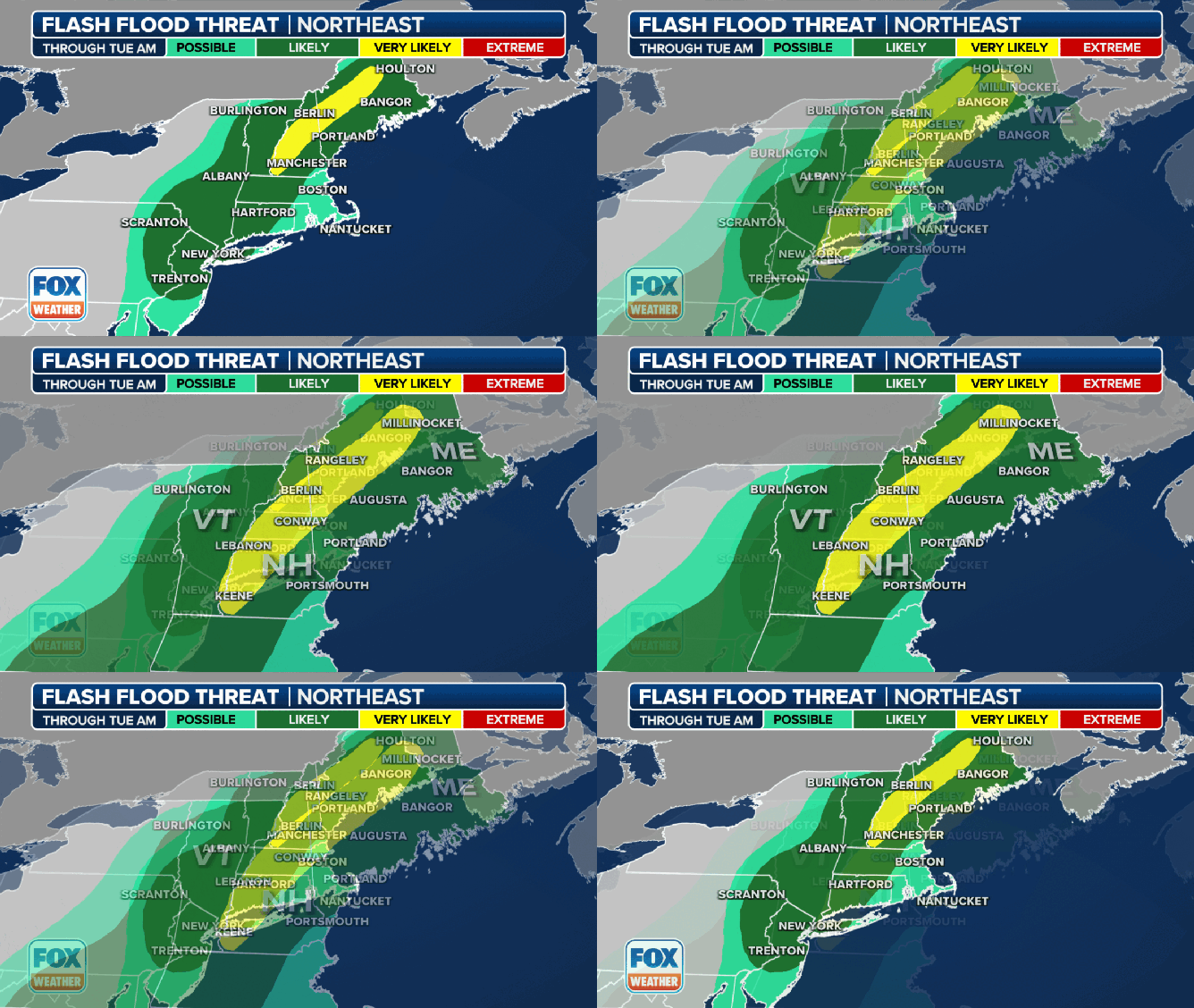
The flash-flood risk in the Northeast and New England on Monday, Dec. 18, 2023.
(FOX Weather)
The heavy rain will likely trigger areas of flash flooding through Monday, with numerous Flash Flood Warnings being issued across the region.
The National Weather Service office in Philadelphia/Mount Holly said flooding was ongoing, with several areas reporting 2 to 5 inches of rain already falling and more expected throughout the day.
Officials were urging drivers not to drive through flooded roadways or go around barricades where roads were closed.
Schools were also closed on Monday, including in Dover, New Jersey, due to the ongoing flooding.
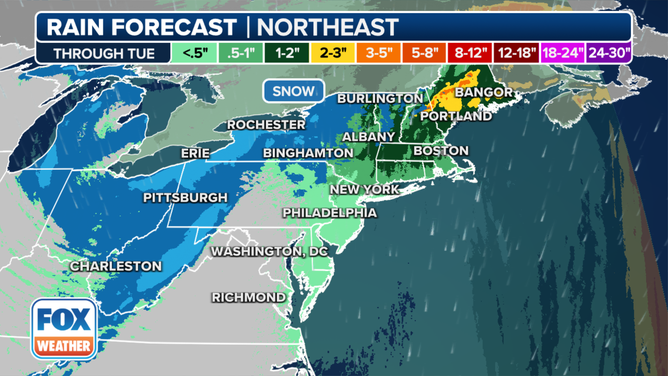
The rainfall forecast through Tuesday, Dec. 19, 2023.
(FOX Weather)
A Flash Flood Emergency was in effect for parts of the South Carolina coast Sunday afternoon.
Residents were urged to stay inside as roads turned to rivers across several communities.
How strong will the winds be along the East Coast?
A High Wind Warning is posted for Monday in parts of coastal New England and Long Island, where wind gusts up to 60 mph are expected. These strong gusts could knock down trees and power lines, leading to additional power outages.
New York City is included in a Wind Advisory that is in effect for Monday along other parts of the Northeast and New England coasts, where gusts between 45 and 55 mph are predicted.
Watch: Winds whipping in Jersey City
Strong winds blow through Jersey City, New Jersey, early Monday morning as a powerful storm races up the East Coast.
Some tree limbs could be blown down in these areas, adding to the numerous power outages across the region.
Unsecured holiday decorations will also be blown around in these gusty winds, so be sure to secure them or bring them indoors until the winds subside.
CHRISTMAS LAWN DECORATIONS ARE SOMETIMES NO MATCH FOR MOTHER NATURE
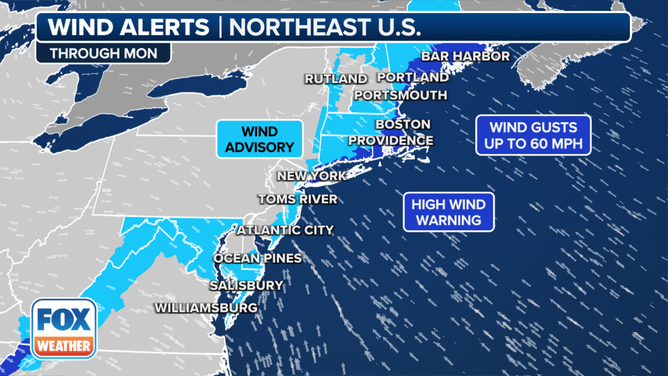
Wind alerts are in effect for parts of the Northeast.
(FOX Weather)
There have already been wind gusts across the region that have reached near hurricane strength (74 mph).
The highest wind gust so far was reported in Barnegat Light, New Jersey, located on the northern tip of Long Beach Island.
Stamford, Connecticut, reported a wind gust of 66 mph, with other locations in New York and New Jersey seeing wind gusts higher than 60 mph.
New York City’s La Guardia Airport saw a wind gust of 54 mph.

The top wind gusts in the Northeast on Monday, Dec. 18, 2023.
(FOX Weather)
Where are severe storms expected?
A few damaging wind gusts are possible from the eastern shore of New Jersey into southern New England through Monday afternoon.
HERE'S WHERE TORNADOES ARE MOST LIKELY TO OCCUR IN EACH MONTH
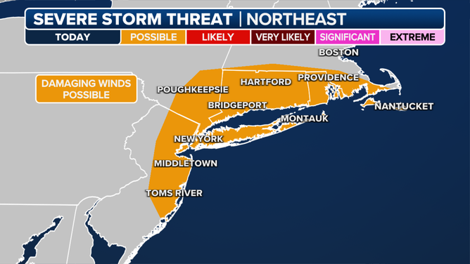
The severe storm threat on Monday, Dec. 18, 2023.
(FOX Weather)
Where are coastal flooding, high surf and beach erosion expected?
Strong onshore winds will create the potential for coastal flooding, high surf and beach erosion along parts of the Eastern Seaboard through Monday.
Coastal Flood Warnings and Advisories extend from the Outer Banks of North Carolina all the way to Maine.
Moderate coastal flooding is possible at high tide from the Chesapeake and Delaware bays to southern New England.
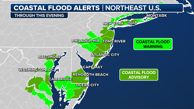
Coastal flood alerts are in effect along the Northeast coast.
(FOX Weather)
The National Weather Service in Boston said significant coastal flooding is expected during the afternoon high tide, which will impact towns along Narragansett Bay in Rhode Island.
The water levels at Fox Point in Providence will likely approach 10 feet. Forecasters say the last time the water levels were that high was observed during Hurricane Bob in 1991 when water levels reached 9.9 feet.
Near-record coastal flooding swamped Charleston, South Carolina, on Sunday afternoon, prompting several road closures in downtown Charleston.
The National Weather Service office in Charleston said the tide in the Charleston Harbor peaked at 9.86 feet (mean lower low water) just before noon local time. Not only is that the highest tide on record not associated with a tropical cyclone, but it's topped only by Hurricane Hugo in 1989, an unnamed hurricane in 1940 and Hurricane Irma in 2017.
CHARLESTON SEES NEAR-RECORD COASTAL FLOODING SUNDAY TOPPED ONLY BY HURRICANES HUGO, IRMA, UNNAMED 1940 STORM

No comments: