‘Largest underwater scanning project in history’ gives never-before-seen view of Titanic
The mysterious 1912 sinking of the luxury passenger liner, the Titanic, has long served as a source of fascination for many.
Historians now believe that a new underwater scanning project may provide answers to some of the unanswered questions regarding the tragedy that killed more than 1,500 people.
A team of scientists have used deep sea mapping to create “an exact ‘Digital Twin’ of the Titanic wreck for the first time,” according to a press release Wednesday from deep sea investigators Magellan and filmmakers Atlantic Productions.
By carrying out the “largest underwater scanning project in history,” scientists have managed to “reveal details of the tragedy and uncover fascinating information about what really happened to the crew and passengers on that fateful night” of April 14, 1912, the press release said.
Scans of the wreck were carried out in the summer of 2022 by a specialist ship stationed 700 km (435 miles) off the coast of Canada, according to the release. Tight protocols prohibited team members from touching or disturbing the wreck which investigators stressed was treated with the “utmost of respect.”
Every millimeter of its three-mile debris field was mapped in minute detail, the press statement said. The final digital replica has succeeded in capturing the entire wreck including both the bow and stern section, which had separated upon sinking in 1912.
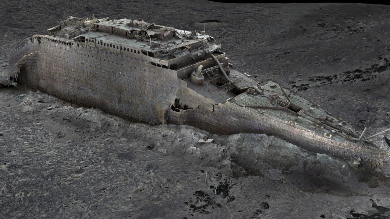
Parks Stephenson, an expert who has been studying the Titanic for 20 years, hailed the project as a “gamechanger” which has managed to unearth “details never seen before.”
“We’ve got actual data that engineers can take to examine the true mechanics behind the breakup and the sinking and thereby get even closer to the true story of the Titanic disaster,” Stephenson remarked.
One such example can be found on the propeller where the serial number can be seen for the first time in decades.
Roughly 715,000 images and 16 terabytes of data were gathered during the expedition – which Magellan estimates to be “approximately ten times larger than any underwater 3D model that’s ever been attempted before,” Magellan CEO Richard Parkinson sa
Parkinson described the mission as “challenging,” referencing the team’s fight against “the elements, bad weather, and technical challenges.”
Whereas previous optical images of the ship were limited by low light level and the poor light quality 12,500 feet below water, the new mapping technique has “effectively taken away the water and let in the light,” the press release said.
According to 3D capture specialist Gerhard Seiffert, the “highly accurate photorealistic 3D model” has enabled people to zoom out and look at the entire wreck “for the first time.”
“This is the Titanic as no one had ever seen it before,” Seiffert added.
According to Stephenson, this mapping will herald the “beginning of a new chapter,” for Titanic research and exploration.


No comments: